|
|
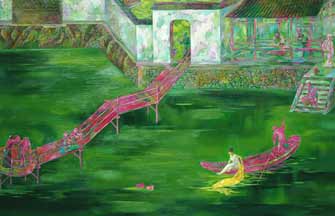
The Mongolia Mountain and Water Map has 211 places marked from Ming Dynasty's frontier Jiayuguan Pass westward to Mecca of Saudi Arabia. |
Researchers have discovered that a document long thought to be a landscape painting from the Qing Dynasty, is in fact one of China's earliest world maps from the Ming Dynasty. Han Bingbin reports.
Matteo Ricci, the Italian missionary who arguably published the first Chinese-language world map during his long stay in China, was believed to be the source of Chinese people's knowledge of world geography. But now a newly appraised Ming Dynasty (1368-1644) world map proves that the Chinese's exploration of world geography had started long before his arrival in 1583.
The Mongolia Mountain and Water Map, a silk hand scroll that measures 30.12 meters long and 0.59 meters in width, marked 211 places from Ming Dynasty's frontier Jiayuguan Pass westward to Mecca of today's Saudi Arabia, named as Tianfang on the map. The "Mongolia" in the map refers to the Mongol Empire that fractured into four khanates.
Stretching over Asia, Europe and Africa, the map covers more than 10 countries which exist today, such as Uzbekistan, Tunisia and Turkey. The Chinese names of the places were transliterated from nine languages including Mongolian, Arabic and Greek. What the map depicts is the exact route of the Ming Dynasty Silk Road, so it's now also known as the Ming Dynasty Silk Road Big Map.
According to Peking University's archaeology professor Lin Meicun, the map was collected by the Kyoto-based Museum of Fujii Yurinkan in the 1930s. But for a long time, it was treated as purely a Qing Dynasty (1644-1911) landscape painting and its real value was not known to the Japanese academic circle.
It was first identified as a Ming Dynasty map by historian Fu Xi'nian in 2002 when the map came back to Beijing after various efforts. From 2004, Lin Meicun embarked on a comprehensive study of the map. The academic value of the map was finally unveiled in a 200,000-word book in 2012, the fruit of Lin's painstaking eight-year research.

After studying the construction period of the buildings on the map, Lin concluded the map was painted between 1524 and 1539. Further evidence, such as block-printed editions of this map, led to a more surprising conclusion that it's highly possible the map was used by the Ming Dynasty's Jiajing Emperor (1522-1566).
Besides its geographical value, Lin says the map possesses great artistic value. There is evidence of influence from the painting style of the Wu school, a party of Suzhou and Wuxi-based literati painters - featuring the well-known Wen Zhengming and Tang Bohu - who were particularly fond of the mountainous landscapes.
The map will tour to Jiayuguan in Gansu province, followed by Beijing, Shanghai, Suzhou and Hainan. It will then be put under the hammer during Poly Auction's spring sales. The map's reserve price is 80 million yuan ($12.8 million).
|
|
|
| Renowned painter donates collection to hometown gallery | Brush with history |


Copyright 1995 - . All rights reserved. The content (including but not limited to text, photo, multimedia information, etc) published in this site belongs to China Daily Information Co (CDIC). Without written authorization from CDIC, such content shall not be republished or used in any form. Note: Browsers with 1024*768 or higher resolution are suggested for this site.
License for publishing multimedia online 0108263 Registration Number: 20100000002731 





 Raymond Zhou:
 Pauline D Loh: My Chinese Kitchen
 Ye Jun:
 China Face
 Hot Pot
 Eco China